About Global Mapper Mobile
Global Mapper Mobile Bring your GIS workflow to the field. Global Mapper Mobile(R) is a powerful Android application for viewing and collecting GIS data. It utilizes the GPS capabilities of mobile devices to provide...
Global Mapper Mobile
Bring your GIS workflow to the field.
Global Mapper Mobile® is a powerful Android application for viewing and collecting GIS data. It utilizes the GPS capabilities of mobile devices to provide situational awareness and locational intelligence for remote mapping projects. A perfect complement to the desktop version of Global Mapper, the mobile app provides maps-in-hand functionality for engineers, surveyors, wildlife managers, foresters, and anyone whose job requires access to spatial data in remote locations.
Global Mapper Mobile can display vector, raster, and elevation data layers that have been transferred from the desktop version of the software. It also provides tools for drawing, tracking, and form-based data collection using pre-configured attributes and picklists.
Global Mapper Mobile Base Version (Free)
The base version of Global Mapper Mobile is free of charge and provides an array of features and functions, including:
• Vector, raster, and terrain data display
• GPS location display
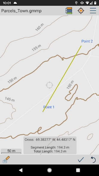
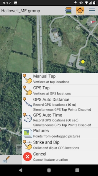
• Point, line, and polygon feature creation using GPS location
• Editing of existing vector features
• Capture of images in the field
• Creation of Picture Points from geotagged images
• Attribute and feature notation recording for new or existing vector features
• Online access to Open Street Map data
Global Mapper Mobile Pro
The Pro version of Global Mapper Mobile, available as an in-app purchase, supplements the functionality of the base version with an array of professional-grade tools, including:
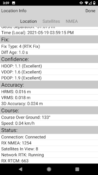
• Advanced GPS support for connection to high-accuracy GNSS devices from vendors such as Bad Elf, EOS, Juniper, and others
• RTK correction via built-in NTRIP client
• GPS Averaging
• Terrain shader and water level display options
• Custom online source options and online data saving for offline use
• Simultaneous feature creation
• Viewshed creation
• Volume calculation
• Data reprojection
• Address searching
• Geopackage and GeoPDF format support
Global Mapper Mobile Pro is available for purchase from the Blue Marble Geographics website. The license is based on an annual subscription from the date of purchase that can be renewed each year. Enterprise licensing options are also available. For more information, email
[email protected].
Note: Continued use of GPS running in the background can dramatically decrease battery life.
Privacy Policy:
https://www.bluemarblegeo.com/privacy-policy/
Terms of Use:
https://www.bluemarblegeo.com/licensing-policy/
Previous Versions
Here you can find the changelog of Global Mapper Mobile since it was posted on our website on 2021-12-11 21:04:57.
The latest version is 2.4.0.12 and it was updated on 2024-04-22 15:46:56. See below the changes in each version.
Global Mapper Mobile version 2.4.0.12
Updated At: 2024-03-11
Changes: Standard (free):
- Raster Info tool
- Digitizer trace mode
- Improved vector, raster, and terrain data render speed
- Dark Theme improvements
- Fix file import issue on Android 13
Pro Subscription:
- Support for viewshed calculation from current GPS location
- Save viewshed point and create viewshed area features
- Expanded volume calculation options to include pile volume and vertex elevation
- Added support for Trimble GNSS devices
Global Mapper Mobile version 2.4.0.9
Updated At: 2023-08-22
Changes: Standard (free):
- Raster Info tool
- Digitizer trace mode
- Improved vector, raster, and terrain data render speed
- Dark Theme improvements
Pro Subscription:
- Support for viewshed calculation from current GPS location
- Save viewshed point and create viewshed area features
- Expanded volume calculation options to include pile volume and vertex elevation
- Added support for Trimble GNSS devices
Global Mapper Mobile version 2.4.0.7
Updated At: 2023-07-11
Changes: Standard (free):
- Raster Info tool
- Digitizer trace mode
- Improved vector, raster, and terrain data render speed
Pro Subscription:
- Support for viewshed calculation from current GPS location
- Save viewshed point and create viewshed area features
- Expanded volume calculation options to include pile volume and vertex elevation
- Added support for Trimble GNSS devices
Global Mapper Mobile version 2.3.0.15
Updated At: 2023-04-13
Changes: Added Bluetooth runtime permission needed for Advanced GPS on Android 12 and above.
Global Mapper Mobile version 2.3.0.14
Updated At: 2023-03-22
Changes: Added mesh bounds to Projection Configuration view
Added Inferno, Magma, Plasma, Viridis, and REM shaders
Added URL test/verification for custom online data sources
Fixed online data layer transparency
Fixed zoom behavior of single point layers
Fixed issues with viewing embedded images
Fixed issue with custom feature styles in template layers
Global Mapper Mobile version 2.2.0.20
Updated At: 2022-05-06
Changes: Added support for scoped storage in Android 11 and above.
Global Mapper Mobile version 2.2.0.18
Updated At: 2022-02-11
Changes: Added support for new Global Mapper Mobile Data Management tool.
Global Mapper Mobile version 2.2.0.12
Updated At: 2021-10-27
Changes: Fixed issue where app was failing to download online data source list.
Disclaimer
Official Google Play Link
We do not host Global Mapper Mobile on our servers. We did not scan it for viruses, adware, spyware or other type of malware. This app is hosted by Google and passed their terms and conditions to be listed there. We recommend caution when installing it.
The Google Play link for Global Mapper Mobile is provided to you by apps112.com without any warranties, representations or guarantees of any kind, so access it at your own risk.
If you have questions regarding this particular app contact the publisher directly. For questions about the functionalities of apps112.com contact us.